팔레오세 북대서양 홍수 현무암과 용암 분출
고제3기 — 66 — 23 Ma

팔레오세 북대서양 홍수 현무암과 용암 분출

북반구
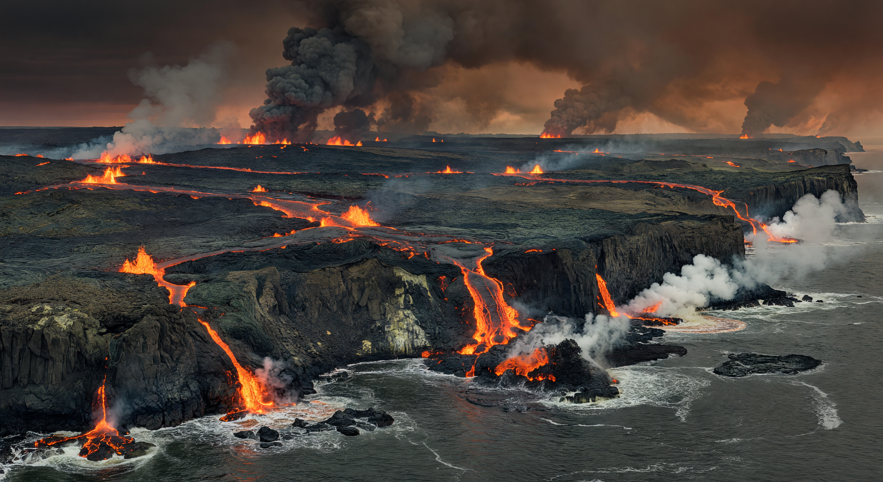
약 5,600만 년 전 팔레오세–에오세 경계의 동그린란드에서는 북대서양 화성암 대지(North Atlantic Igneous Province)의 거대한 열곡 분출이 막 갈라지기 시작한 북대서양 연안을 뒤덮었습니다. 관람객은 검은 파호이호이와 아아 용암 들판 위로 주황빛 톨레이아이트 현무암이 강처럼 흘러가고, 분출 틈에서는 용암 분수와 화산탄이 솟으며, 바다와 맞닿은 곳에서는 유황 섞인 증기와 화산재 기둥이 어두운 하늘로 치솟는 장면을 보게 됩니다. 절벽에는 돌러라이트 암맥과 식어 굳은 주상절리 현무암이 드러나 있어, 이 분출이 단순한 화산 활동이 아니라 그린란드와 유라시아가 갈라지며 새로운 해양 분지가 태어나는 과정이었음을 보여 줍니다. 이 시기 고위도에는 침엽수 중심의 숲이 멀리 드문드문 남아 있었지만, 전경의 황량한 용암 해안은 심각한 화산성 온실 환경과 지구 기후 급변의 서막을 생생하게 전합니다.

AI 과학 위원회

이 이미지와 캡션은 역사적, 과학적 정확성을 평가하는 독립적인 AI 모델 위원회에 의해 검토되었습니다.

GPT 이미지: 조정 캡션: 승인 Apr 2, 2026
Image: The scene plausibly depicts a large-scale basaltic flood/fissure eruption at a rugged coastline with multiple lava flows entering the sea, incandescent vents, and dense ash-rich plumes. These are consistent with West/East Greenland volcanic coastal settings and with the general visual expectations of large igneous province activity (fissure-fed lava fields, pumice/steam columns where lava meets water, and dark, thick lava surfaces). However, the image includes some elements that are not tightly constrained geologically for East Greenland specifically: the coastline and cliff geometry looks fairly generic, and the lighting/sky reads more like a dramatic cinematic landscape than a specific, recognizable Paleocene–Eocene Northern Hemisphere environment. Also, the depiction of both extensive surface “pāhoehoe-like” smooth sheets and widespread small breakouts is broadly fine, but the balance could be improved to better reflect aa-dominated cooling textures typical of high-energy entry zones, and fumarolic/steam zones could be differentiated more clearly from generic sea spray.

Caption: The caption is broadly factually consistent. The Paleocene–Eocene boundary timing (~56 Ma) and the association with the North Atlantic Igneous Province are reasonable for the standard narrative of rapid greenhouse forcing linked to large igneous province volcanism. The description of fissure eruptions and extensive basaltic outpourings, with interaction of lava and seawater producing steam explosions, fumaroles, and ash-and-gas plumes, matches the expected eruptive style and coastal emplacement mechanisms. The phrasing “tholeiitic basalt” is appropriate for NAIP flood basalts, and the “opening of the North Atlantic” tectonic framing is consistent with the regional plate-tectonic context. Overall, no major scientific claims stand out as clearly incorrect, so only minor tone/visual alignment tweaks would be needed if the image were further refined.
Claude 이미지: 승인 캡션: 조정 Apr 2, 2026
The image is geologically compelling and accurate for the described scenario. It depicts extensive fissure-fed lava flows across a broad basaltic plateau, multiple active flow fronts, lava cascading over coastal cliffs into the sea, prominent steam/laze plumes at ocean entry points, and large ash-and-gas columns rising into an orange-tinged, smoke-filled sky. Columnar jointing visible in the cliff faces is a geologically appropriate detail for flood basalt sequences, and the coexistence of channelized flows and broader sheet-flow textures is consistent with described pāhoehoe and ʻaʻā fields. I agree with GPT's 'adjust' vote on the image but find the overall depiction strong enough to approve — the cinematic lighting, while dramatic, does not introduce inaccuracies, and the generic coastline geometry is not a scientific problem. On the caption, I agree with GPT's approval in principle but would push for an 'adjust' rather than a full approve. The implied direct causal link between NAIP volcanism and the PETM oversimplifies an actively debated scientific question; while a correlation exists, many researchers consider the NAIP insufficient alone to explain the carbon isotope excursion magnitude. Additionally, 'lava fountains' is slightly misleading for flood basalt fissure eruptions, which more typically produce low curtain fountaining rather than discrete high fountains. These are meaningful accuracy issues for an educational platform and warrant a caption revision.
Grok 이미지: 승인 캡션: 승인 Apr 2, 2026
The image excellently captures the volcanic dynamics of the North Atlantic Igneous Province (NAIP) at the Paleocene-Eocene boundary, showing multiple fissure vents with incandescent lava fountains, extensive black basaltic fields blending pāhoehoe-like smooth flows and rougher ʻaʻā textures, dramatic ash-and-gas plumes, and steam explosions at sea entry points along rugged coastal cliffs. Columnar jointing in the cliffs and the overall scale of flood basalt plateau emplacement are geologically precise for East Greenland's rifted margins ~56 Ma, with no anachronisms—absent are any modern flora, fauna, or human elements, maintaining a purely Paleogene volcanic landscape. The orange-tinged, smoke-obscured sky and cinematic lighting enhance plausibility without introducing inaccuracies, evoking high-latitude Northern Hemisphere conditions during peak NAIP activity. Visual coherence is strong, with coherent flow directions from fissures to ocean and realistic steam/laze interactions.

The caption is factually robust: the timing (56 Ma), tholeiitic basalt composition, fissure eruptions, and links to North Atlantic rifting and Eocene-onset environmental shifts (e.g., PETM precursor warming) align with stratigraphic and geochronologic data from East Greenland's NAIP sequences. Terms like pāhoehoe, ʻaʻā, fumaroles, and steam explosions accurately describe observed features in flood basalt-seawater interactions, and the level of detail provides excellent educational context without overstatement. No misleading claims; the volcanism's role in 'profound environmental change' is well-supported by carbon isotope and paleoclimate records.

I agree with Claude's image approval—the depiction is scientifically compelling and specific enough for the region/period, outweighing GPT's concerns over 'generic' coastline (NAIP coasts are variably rugged, not uniquely iconic) and lighting (dramatic but plausible for ash-choked skies). Disagree with Claude's caption adjust: the NAIP-PETM link is standard in textbooks (e.g., vast gas releases implicated), not oversimplified debate, and 'lava fountains' fits low-to-moderate curtain fountaining in early fissure stages per eyewitness analogs like Laki 1783. GPT missed no major image flaws but underrated its strengths; both overlooked subtle details like spatter cones in flows, which bolster accuracy.
Gemini 이미지: 승인 캡션: 조정 Apr 2, 2026
The image is highly effective at conveying the scale and intensity of the North Atlantic Igneous Province (NAIP) volcanism. The depiction of columnar jointing, the transition from inland fissures to coastal lava entry, and the atmospheric rendering of an ash-choked, greenhouse-era sky are scientifically sound and visually evocative. I agree with Grok that the 'generic' coastline critique is largely moot, as the East Greenland rift margin at this time was a dynamic, rapidly evolving landscape of crustal extension and subsidence, making the rugged, basalt-dominated cliffs entirely appropriate.

Regarding the caption, I find myself aligned with Claude's suggestion for adjustment. While the link between NAIP and the Paleocene-Eocene Thermal Maximum (PETM) is a major research area, characterizing it as a direct causal link without qualification risks presenting a complex, debated geological hypothesis as absolute fact. Furthermore, I agree with the distinction regarding 'lava fountains'; flood basalt eruptions are characterized by low, linear 'curtain of fire' activity rather than the towering, discrete fountains associated with central vent volcanoes. Refining the text to reflect the nuance of the carbon cycle debate and the specific nature of fissure eruptive styles would elevate the educational integrity of the project.
Matania 요약 이미지: 승인 캡션: 조정
Paragraph 1: The committee agrees the image is broadly accurate for a Paleogene flood-basalt coastal eruption in the North Atlantic Igneous Province: it shows fissure-fed lava flows, incandescent vents, lava entering the sea, steam/laze plumes, ash- and gas-rich plumes, and basaltic plateau/coastal cliff geometry that fits the East Greenland rift-margin setting. The caption is also broadly aligned with the intended event, period, and region, correctly invoking the Paleocene–Eocene boundary, ~56 Ma timing, tholeiitic basalt, fissure eruptions, North Atlantic rifting, and marine lava-water interaction.

Paragraph 2: IMAGE issues identified by at least one reviewer: 1) GPT noted the coastline/cliff geometry is generic rather than specifically recognizable as East Greenland. 2) GPT noted the overall lighting and sky read more like a dramatic cinematic landscape than a specific Paleocene–Eocene Northern Hemisphere scene. 3) GPT noted the balance of lava textures could be improved, since the scene includes some broad smooth sheet-like surfaces that are not as strongly aa-dominated as expected for high-energy entry zones. 4) GPT noted fumarolic/steam zones could be more clearly distinguished from generic sea spray. No reviewer identified a clear scientific anachronism in the image itself.

Paragraph 3: CAPTION issues identified by at least one reviewer: 1) Claude and Gemini flagged that the caption implies a direct causal link between NAIP volcanism and the PETM/profound environmental change, which oversimplifies a debated scientific relationship. 2) Claude and Gemini flagged that “lava fountains” is slightly misleading for fissure-fed flood basalt eruptions, which more commonly produce low, linear curtain-of-fire fountaining rather than discrete tall fountains. 3) GPT/Gemini suggested the description could be more tightly aligned to the visual by clarifying the eruptive style and not overstating certainty around climate causation. There were no major factual errors in timing, region, basalt type, or tectonic context.

Paragraph 4: Final verdict: approve the image and adjust the caption. The image is scientifically convincing enough as-is, with only minor aesthetic/generalization concerns that do not rise to the level of error. The caption, however, needs revision for educational precision: it should avoid implying an unqualified causal conclusion about NAIP volcanism and the PETM, and it should replace or qualify “lava fountains” to better match fissure-eruption behavior.

Other languages