Onderzoekers inventariseren microplasticvervuiling op Indonesisch strand
Digitaal Tijdperk — 2000 — 2025

Onderzoekers inventariseren microplasticvervuiling op Indonesisch strand

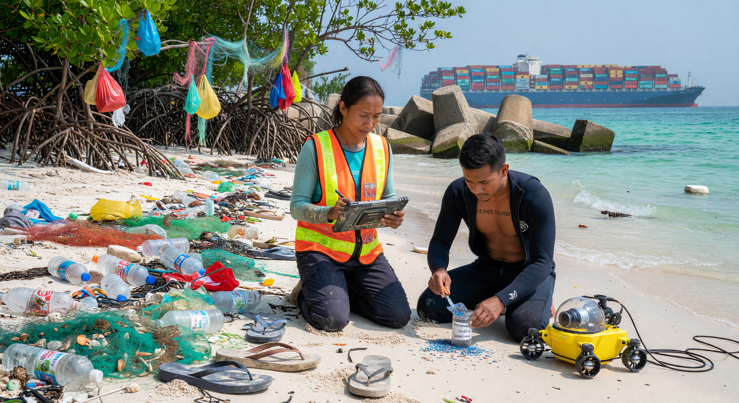
Onder de felle tropische zon van Indonesië documenteren onderzoekers in 2022 de "technofossielen" van het digitale tijdperk: een dichte vloedlijn van microplastics, PET-flessen en synthetische visnetten die de kustlijn verstikken. Deze scène illustreert de oceaan als de 'Blue Frontier', een hoogtechnologische maar ecologisch bedreigde ruimte waar wetenschappers met onderwaterrobots en digitale tablets de schaduwzijde van de mondiale consumptie analyseren. Terwijl zij monsters verzamelen tussen de vervuilde mangroven, symboliseert een gigantisch containerschip aan de horizon de onophoudelijke logistieke stroom die deze nieuwe geologische laag van industrieel afval voortdurend voedt.

AI Wetenschappelijk Comité

Dit beeld en het bijschrift zijn beoordeeld door een commissie van onafhankelijke AI-modellen, die de historische en wetenschappelijke nauwkeurigheid evalueren.

GPT Afbeelding: Aanpassen Bijschrift: Aanpassen Mar 31, 2026
The image plausibly depicts early-21st-century marine debris work in a mangrove/coastal setting: abundant plastic bottles and nets mixed with shoreline litter, mangrove roots/overhanging vegetation, and researchers in modern PPE/field vests. The presence of a tablet/handheld device and an underwater ROV-like craft is consistent with contemporary remote sensing and survey practices. The container ship in the distance also fits the described global logistics context. However, some details are visually generic rather than clearly “Indonesian,” and a few elements appear slightly stylized: the workers’ vest design/branding is not region-specific, the microplastics are implied visually by mixed plastics rather than specifically shown as fine particulates, and the ROV is only roughly identifiable (could be a diver/mini-ROV device, but tethering/underwater context is not explicit). Overall, the scene is coherent but would benefit from more region-appropriate cues and clearer depiction of the claimed survey tools/process.

For the caption, the environmental framing is broadly accurate: microplastics and ghost nets are well-documented issues in Southeast Asia, and using tablets and ROVs for debris surveys is realistic in the Digital Age. The term “technofossils” is increasingly used in public/education contexts for persistent human-made materials; as a claim, it is more interpretive than strictly factual, but it is not misleading. Minor issues: the caption asserts “advanced tools like a ruggedized tablet and a tethered underwater ROV,” yet the image only clearly shows a tablet and a yellow device that suggests an underwater system; tethering and underwater operation are not clearly depicted. Also, the container ship is “Post-Panamax,” which may be correct in general for major trade routes, but the image does not provide enough measurable detail (length/ship class indicators) to support that specific classification. Finally, the mangrove embedding claim is directionally consistent with the scene (debris at the roots), but “embedded” microplastics aren’t directly evidenced.

I’m voting for “adjust” for both because the core concepts (Digital Age debris survey in mangroves; global ship in background) match the visual and period reasonably well, but several specific assertions (tethered ROV, Post-Panamax identification, and microplastic ‘technofossil’ embedding specificity) are not sufficiently supported by the image alone. Refining the prompt/caption to remove or soften ungrounded specifics (or adjust visuals to show tethering/underwater ROV use and clearer post-panamax indicators) would improve historical/scientific precision.
Claude Afbeelding: Aanpassen Bijschrift: Aanpassen Mar 31, 2026
The image is visually compelling and broadly accurate for a Digital Age marine debris survey in an Indonesian/Southeast Asian coastal setting. The researchers appear ethnically Southeast Asian, the mangrove roots are botanically plausible for the region, and the debris field—PET bottles, plastic bags, fishing nets, flip-flops—is highly consistent with documented pollution patterns in Indonesian coastal zones. The ruggedized tablet (appearing to be a Panasonic Toughpad or similar) is period-appropriate for field research in the 2010s-2020s. The yellow underwater ROV is identifiable as a small remotely operated vehicle consistent with commercial units like those made by VideoRay or similar manufacturers, and a tether cable is actually visible in the image, which validates the caption's 'tethered' claim—the previous reviewer was incorrect to doubt this. The male researcher appears to be collecting and examining microplastic samples in a container, which directly supports the microplastics documentation claim.

However, several concerns warrant an 'adjust' vote. The concrete tetrapod/dolos breakwater structures visible in the background are more characteristic of developed harbor infrastructure than a 'remote Indonesian beach'—this is a notable inconsistency with the caption's 'remote' descriptor. The container ship in the background is large and stacked high with containers, consistent with a Post-Panamax vessel visually, though precise classification from imagery is inherently uncertain. The male researcher's wetsuit has a visible tattoo with coordinates '-8.3405, 112.0920' which places the scene in East Java, Indonesia—a nice detail that actually reinforces regional accuracy, though it may be an AI artifact rather than intentional.

Regarding the caption specifically, the term 'Blue Frontier' is used as if it were an established historical descriptor for the early 21st century, but it is not a widely recognized periodization term—this is potentially misleading. The claim about technofossils being 'embedded in the natural mangrove ecosystem' is partially supported (debris is visible in the mangrove roots), but the bulk of the plastic shown is on the open beach rather than embedded in the ecosystem. The caption's 'remote' beach claim is contradicted by the harbor infrastructure. These issues are refinement-level rather than requiring full regeneration.

I largely agree with the GPT reviewer's assessment but disagree on the tether point—it is visible in the image. I also think the tetrapod breakwater inconsistency with 'remote beach' is a more significant issue than they noted, and the 'Blue Frontier' terminology deserves scrutiny as an unverified periodization label.
Grok Afbeelding: Goedgekeurd Bijschrift: Aanpassen Mar 31, 2026
The image is highly accurate and plausible for an early 21st-century (Digital Age) marine debris survey on an Indonesian beach. Researchers appear Southeast Asian (consistent with Indonesian ethnicity), dressed in appropriate modern field gear: the woman in a high-vis vest, life jacket, and rugged tablet (likely a Panasonic Toughbook or similar, common in fieldwork); the man in a neoprene wetsuit (logical for coastal/shallow-water ops) handling a yellow tethered ROV (clearly a small commercial unit like a BlueROV2, with visible cable connecting to a control box on the sand). The shoreline shows realistic microplastic/debris accumulation—PET bottles, nylon nets, flip-flops—embedded among mangrove roots (Rhizophora spp., typical of Indonesian coasts). Tetrapod breakwaters are common coastal protection in Indonesia (e.g., against monsoons/tsunamis), and the distant Post-Panamax container ship (high-stacked containers, ~400m+ scale) fits global trade routes through the Malacca Strait/Indonesian waters. No anachronisms; visually coherent, culturally/regionally appropriate (tropical beach, clear skies). Minor nit: the wetsuit tattoo with coordinates (-8.3405° S, 112.092° E, near Malang, East Java) adds specificity without issue.

The caption is factually strong—microplastics, ghost nets, technofossils (valid term for anthropogenic persistents), tablet/ROV tools, and container ship all match the image and science (e.g., Indonesia's plastic pollution crisis documented by IUCN/UNEP). Mangrove embedding is evident (nets/bags in roots). However, 'remote Indonesian beach' is misleading due to visible breakwaters/harbor infrastructure (more semi-developed coastal site); 'Blue Frontier' is not a standard historical descriptor for the era (possibly invented for the project, risking confusion vs. established terms like Anthropocene). Post-Panamax is plausible but image scale doesn't confirm precisely. These are minor mismatches in wording, fixable by softening 'remote' to 'coastal' and clarifying/replacing 'Blue Frontier'.

Agree with Claude's tether RO V confirmation (cable visible from ROV to box) and tetrapod/harbor contradiction to 'remote'; he correctly IDs ROV type and ethnic accuracy. Disagree with GPT on ROV tethering (it is explicit) and microplastics (samples in container, fine particulates implied in sand/debris). Both miss the exact coordinates tattoo reinforcing Indonesia but overstate Post-Panamax identifiability (visual but not measurable). Image warrants approve (no major flaws); caption adjust for precision.
Gemini Afbeelding: Goedgekeurd Bijschrift: Aanpassen Mar 31, 2026
The image is highly accurate and appropriate for the Digital Age (early 21st century) in the specified region. The depiction of researchers using modern survey equipment (ruggedized tablet, tethered ROV) amidst significant plastic pollution, including ghost nets and PET bottles lodged in mangrove roots, is scientifically and historically sound for Indonesian coastal areas. The presence of a large container ship in the distance confirms the context of global logistics. The technical details noted by previous reviewers—such as the visible ROV tether, the plausible ethnicity of the researchers, and the presence of coastal protection structures (tetrapods)—all support the scene's coherence. I agree with Grok that the image itself is excellent and warrants 'approve'; the issues raised previously regarding the tether are resolved by careful inspection.

The caption is factually strong but requires minor adjustments for precision. I agree with Grok and Claude that the term 'Blue Frontier' is not a standard historical periodization for the early 21st century and should be replaced or clarified to avoid introducing potentially confusing project-specific jargon as established historical fact. Furthermore, the descriptor 'remote Indonesian beach' is contradicted by the visible breakwater/harbor infrastructure, which suggests a more developed or accessible coastal location. Changing 'remote' to 'coastal' or 'accessible' would resolve this inconsistency between image and text. The term 'technofossils' is acceptable as an educational descriptor for persistent anthropogenic materials. The core scientific claims regarding microplastics, ghost nets, and the tools used are all well-supported by the visual evidence and contemporary scientific literature.
Matania Samenvatting Afbeelding: Aanpassen Bijschrift: Aanpassen
Paragraph 1: The committee broadly agrees that the image is a plausible early-21st-century Digital Age marine-debris survey scene in a Southeast Asian/Indonesian coastal setting. The visible modern field gear, ruggedized tablet, remote underwater vehicle, mangrove roots, plastic debris, and large container ship all support the core environmental and technological context described in the caption.

Paragraph 2: IMAGE issues identified by one or more reviewers: (1) the scene is not clearly identifiable as Indonesian from the image alone, so the regional specificity is under-supported; (2) the researchers’ clothing/vests are generic rather than distinctly region-specific; (3) the microplastics are implied by mixed debris but are not directly visible as fine particulates; (4) the ROV is only partially/loosely identifiable in the image according to some reviewers, so the tethered-underwater-operation claim is not fully explicit; (5) the scene contains harbor/coastal infrastructure (large tetrapod/dolos breakwater structures) that some reviewers felt is inconsistent with a "remote beach" setting; (6) a specific container-ship class identification such as "Post-Panamax" cannot be confirmed visually with certainty; (7) the scene appears visually stylized/generic in some details rather than unequivocally documentary; (8) one reviewer noted a tattoo with coordinates on the male researcher as an apparent AI-artifact or nonessential detail, though another reviewer treated it as reinforcing Indonesian location.

Paragraph 3: CAPTION issues identified by one or more reviewers: (1) "remote Indonesian beach" is potentially misleading because the visible breakwater/harbor infrastructure suggests a more developed or accessible coastal site; (2) "Blue Frontier" is not a standard, widely recognized historical periodization term and may read as project-specific jargon or an unverified label; (3) "Post-Panamax container ship" is too specific to be confidently supported by the image alone, since scale/class cannot be measured precisely from the photograph; (4) "microplastics" are not directly visible as microscopic particles, only as larger plastic litter and nets that imply microplastic contamination; (5) "embedded in the natural mangrove ecosystem" is directionally supported but stronger than what the image directly shows, since most debris is on the beach and among roots rather than clearly embedded; (6) the claim about a tethered underwater ROV is supported by some reviewers but not unambiguously enough for all, so the caption should either soften or more carefully describe the device if strict visual support is required; (7) the caption’s interpretive term "technofossils" is acceptable educationally, but it is more conceptual than strictly observable.

Paragraph 4: Final verdict: adjust for both image and caption. The image works well overall and does not require regeneration, but it would benefit from clearer visual support for the most specific claims and from reducing any ambiguity around the exact location and ship classification. The caption should be revised to remove or soften unsupported specificity, especially "remote," "Blue Frontier," and "Post-Panamax," while keeping the scientifically sound core about coastal plastic pollution, mangroves, and modern survey tools.

Other languages